Outdoor Recreation:
Sugarbush/Mad River
Valley
The Sugarbush / Mad River Valley is located in Central Vermont
and includes the towns of Warren, Waitsfield, Fayston, Moretown,
and Duxbury . The valley is bordered on one side by farmlands
and the Mad River and on the other, the Green Mountains.
Material Compiled By Frank Partsch of The
Sugartree Inn, Warren VT
Summer
Canoeing
Fishing, and Guide Service
Golf
Hiking
Hunting
Horseback Riding
Mountain Biking
| | Road Biking | |
Back Road Biking
Soaring
Walking
Sight Seeing / Points of Interest
Winter
Downhill Skiing
Cross Country Skiing
Snowmobiling
Snowshoeing
Sleigh Rides
Canoeing
Mad River in April, May and sometimes June
White River in April, May and sometimes June
Winooksi River all spring, summer and fall
Waterbury Reservoir until it freezes.
*Rebuilding of dam may restrict use.
Rentals are available locally from Clearwater
Sports in Waitsfield. They will also arrange guided day trips,
full moon cruises or shuttle trips. The valley is the home of
Mad River Canoe, there is a factory showroom.
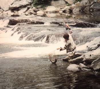
Fishing
|
Central Vermont offers a variety of warm-water and cold-water
fishing opportunities. Sections of two of Vermont's largest and
most productive trout streams, the Lamoille and Winooski rivers,
as well as the Waterbury and Green River reservoirs are found
here. It is also home to the Dog River, one of Vermont's top
wild trout streams, and the Woodbury-Calais Lakes Region, which
offers good to excellent fishing for trout, bass, and panfish.
Fish commonly found in Vermont's waters include landlocked
salmon, yellow perch, brook trout, lake trout, brown trout, rainbow
trout, largemouth and smallmouth bass, and northern pike. Among
the most popular ice fishing species are salmon, lake trout,
walleye, and northern pike.
Open water fishing season in Vermont begins the second Saturday
in April, when the statewide season for trout and salmon opens
on inland lakes and streams. Ice fishing season on lakes with
no trout & salmon begins with the onset of safe ice, usually
late December or early January. Most large cold water lakes that
have a closed season for trout and salmon also have a special
ice fishing season for trout, salmon, and bass that opens on
the third Saturday in January and closes the second Sunday in
March. Check the guide to Hunting, Fishing, and Trapping Laws
for regulations on the water you intend to fish. It is available
free at all hunting and fishing license agents. You may also
contact the Vermont Fish and Wildlife Department at 802-241-3700
or look them up on the web at www.anr.state.vt.us/fw/fwhome
|
 Fly Fishing
The Mad River Valley has numerous streams to explore
on your own or with a guide. There are several guide services
also offering instruction. Vermont Fishing License is required.
They Are:
| Brookies
Guide Service |
Montpelier & Middlebury |
George & Karen Clifford |
802-456-1399 |
| Clearwater Sports |
Waitsfield |
|
802-496-2708 |
| Fly Fishing |
Warren |
Ron Majorell |
888-459-9183 |
| R & L Archery |
Barre |
|
802-479-9151 |
| Reel Vermont |
CALAIS |
Don Heise |
802-223-1869 |
| Uncle Jammer's Guide Service |
Underhill |
James Ehlers |
800-805-6495 |
| VT Fly Fishing Guides |
Waitsfield |
Andy Yager |
802-496-6387 |
Brookies Guide Service
is a licensed, professional guide service providing you with some
of the finest fly fishing in central and northern Vermont. From
native brook trout in back country streams to rainbows and browns
in the ponds and rivers, there is excellent fishing throughout
the season.
Golf
The Sugarbush Golf Course is a Robert Trent Jones Sr. designed
beautiful and challengeing 18 hole mountain course. 802-583-6725
Other courses nearby include :
- Barre Country Club, Plainfield Rd Barre, 18 holes 802-476-7658
- Blush Hill Country Club, Blush Hill Rd, Waterbury 9 holes
802-244-8974
- Montague Country Club, Randolph Ave, Randolph 18 holes 802-728-3806
- Montpelier Golf Club, Country Club Rd, Montpelier 9 holes
802-223-7457
- Northfield Country Club, Roxbury Rd, Northfield 9 holes 802-485-4515
- Stowe Country Club, Cape Cod Rd, Stowe 18 holes 802-253-4893
- White River Golf Club, Rt 100, Rochester 9 holes 802-767-4653
Hiking
Being bordered on two sides by mountains make for some very
good day hikes. We are also adjacent to the LongTrail, making
the Sugarbush / Mad River Valley a perfect place to resupply and
rest if you are doing the Long Trail.
Dolomite Trekking Center at Sugarbush Sugarbush
Ski Area home of classic Vermont terrain and Dolomite, craftier
of classic high mountain footwear have teamed up with the US Forest
Service and the Green Mountain Club to offer a variety of trekking
opportunities.
Choose varying degrees of challenge, from guided ecological
treks to more difficult adventures to the 3,975 ft summit of Lincoln
Peak and on to the Long Trail.
A Dolomite rental shop is on site
Here are a few day hikes there are many more:
Mt. Abraham Elevation 4006'
3-4 hours roundtrip, elevation gain 1,600', 5.2 miles. This popular
hike is usually done from Lincoln Gap. Off Rt 100 in Warren trail
head is on Lincoln Gap Rd. Park at the top of Lincoln Gap and
follow the Long Trail north for 2 1/2 miles passing the Battell
Shelter after 1.8 miles. The rocky summit is above timberline
offering panoramic views. This is a well traveled trail and a
good hike for kids. Descend by the same route. Lincoln Peak is
0.8 miles farther north on the Long Trail and the descent from
here by the ski trails(Sugarbush South Basin) is sometimes done.
Sunset Rock 2424'
One Hour roundtrip, elevation gain 500', distance 1.5miles. A
favorite easy hike to a dramatic spot. Great views to the west
towards Lake Champlain and the Adirondacks. Off Rt 100 in Warren
trail head is on Lincoln Gap Rd, Park at the top of Lincoln Gap
and follow the Long Trail south. Trail climbs steeply at first
then gently up and down before opening abruptly onto Sunset Ledge.
Mt Ellen - Sugarbush Loop
4-6 hours Roundtrip, elevation gain 2,500', 5.5 miles. From the
parking lot at Sugarbush North, follow the service road to the
top of Mt. Ellen 4083', this is the left side of the ski area.
From here follow the Long Trail south 1.6 miles to the Castlerock
chair lift at South Basin. Walk down the ski runs to the South
Basin parking area. Mt. Ellen offers the highest lift served skiing
in Vermont and is tied with Camels Hump for the third highest
mountain in Vermont. Only Mt Mansfield (4393') and Killington
(4241') are higher.
Appalachian Gap to Lincoln Gap
5-8 hours one way, one way distance 11.6 miles. Either take the
Long Trail south from App Gap or the Long Trail north from Lincoln
Gap. From the north, Mt. Ellen (4083') is reached after 5.3 miles
and Lincoln Peak after 8.2 miles. An arduous, but very rewarding
hike offering beautiful views from the high, rugged and at times
very narrow ridge of the Green Mountains. This is a classic hike
- although many know about it few have done it. Take precautions
with regards to the weather and make sure you are up to it physically.
It is a high and exposed ridge, and although there are escape
routes down the ski runs, you will want to be well prepared in
case you are overtaken by stormy weather.
General Stark Mountain 3662'
4-5 hours roundtrip, elevation gain 1,285', 6.2 miles.Off Rt 100
take Rt 17 to the Appalachian Gap. Take the Long Trail South for
3.1 miles to the summit, passing the top of the Mad River Glen
Ski area. There are three overnight shelters near there. (Theron
Dean, Stark's Nest, and Glen Ellen Lodge)
Camels Hump 4083'
3-5 hours roundtrip. For many this distinctive peak offers the
finest mountain hike in Vermont. From the top the view is like
that from an airplane - the mountain is at your feet. Of the higher
peaks it is the only one undeveloped: no ski lifts, no roads,
no radio towers. The summit area is above timberline and supports
artic-alpine tundra vegetation. Off Rt 100 in Duxbury turn onto
River Rd and proceed 4.5 miles to a three way intersection. Turn
left for 3.5 miles to the parking area. Summit is 3.4 miles by
the well maintained Forestry Trail. Views of the White Mountains,
Adironacks, and in Vermont from Mt Mansfield south to Mt Ascutney.The
trail is open from spring to late fall. A popular variation is
to take the Dean Trail (left off the Forestry Trail) to Wind Gap
on the Long Trail and then the Long Trail north to the summit
descending by way of the Forestry Trail. 4-6 hours roundtrip.
Note trail intersections carefully to avoid confusion on the return!
There are many other day hikes in the area . For other reference
call the Green Mountain Club, at 1-802- 244-7037 or consult the
guide book of the Long Trail and the Day Hikers Guide to Vermont
published by the Green Mountain Club or 50 Hikes in Vermont published
by Countrymans Press. If you have another favorite hike in the
North Central Vermont Area let us know and we will add it to the
list.
Horseback Riding
Central Vermont
provides a wide range of options for those interested in riding,
in addition to the Mad River Valley hosting three weeks of The
Vermont Equestrian Showcase.
Autumn
Harvest Inn & Restaurant (802)-433-1355.
Riding packages offered in conjunction with Autumn
Phoinix Riding Stables. Eighteen-room country inn located
just a few miles from Birch Meadow. Spectacular views. Two nights
or more with riding and some meals included. Weekend
or mid-week packages.
Vermont Icelandic Horse Farm (802) 496-7141. Tour the Mad River Valley's mountains,
meadows and forests on one of the oldest breeds in the world.
The tireless and efficient movement of the Icelandic Horse makes
them the ideal saddle horse, seeming to effortlessly dance over
the earth with lightness and power. Ride in any season.
Other stables include:
Dana Hill Stable. Group lessons, packages and extensive coaching
weeks. For adults and children. Rt 17, Fayston 802-496-6251
Mad Mountain Ranch. Western trail rides for all ages and abilities.
Rt 17 Waitsfield 802-496-5396
Mad River Stables. Private or semi private lessons, your horse
or ours. Old Route 100 (Off Rt. 100B), Moretown Vt 802-223-2359
Navajo Farm. Riding instruction and trail rides, Reservations
needed. Rt 100 Moretown Vt 802-496-3656
Vermont Icelandic Horse Farm. Pony treking tours by the 1/2
day and full day. Common Rd Waitsfield Vt 802-497-7141.
Viking Horse Farm, Icelandic Horse Center Riding instruction,
trail rides horses sold and trained. Off Airport Rd Warren VT
802-583-4450.
Mountain Biking
The Mad River Valley is home to some of the best mountain biking
in the country. The trememdous variety of terrain from smooth
dirt roads to technical single track, offers riders of all abilities
endless miles of riding.
One of the local bike shops rent mountain bikes and provides
guided regularly scheduled tours. For specific information and
details about the Mad King Challenge (the ultimate test) call
802-583-6572 weekends only. Rentals:Clearwater Sports 802-496-2708.
The Sugarbush Mountain Bike Center
The Mountain Bike center offers excursions for all ability
levels from on road beginner to an expert single track race loop.
A Dual Slalom Course and a Moto Park
with a variety of terrain diversions are permanantly set up for
all bikers. Guided Mountain Bike Tours 10 AM
and 1PM, two hours of instruction and an introduction to the designated
trail networks. An accessory retail and basic repair bike shop
is at your disposal. Pro Flex 455 Mt Bikes and helmets are available
for rent.
The rides given here are on town or other public roads or areas.
There are other rides commonly done that may or may not be on
private property. Obtain permission if in doubt and respect property
owner signs.
Plum Creek Road Climb 6 miles
From Rt 100, ride up Rt 17 0.2 miles, taking the gravel road left
immediately following the lumber mill. This is a long and steep
climb which starts out very steeply. If you can do this ride without
stopping, you are in good shape. about a 20 minute climb. Not
much in the way of views until you reach the small house at the
end of the main track. Descend by the same route.
Tucker Hill Rd 5 miles
From Rt 100 in Waitsfield ride about 0.6 mile on Rt 17 to tucker
Hill Rd on your left. This is a moderately steep gravel road about
1.8 miles long which takes you past old farms and newer homes.
The views toward bragg Hill get better and better as you climb.
Return by the same route.
North and Center Fayston Loop
From Waitsfield, ride north on Rt 100 to Center Fayston Rd. Ride
up this for 1.4 miles to Carey/Strong Rd., turn right, bear right
at a fork soon after, and after an easy mud section in dense woods
(1.4 miles), you emerge in the North Fayston Basin. Head left
on Airport Rd to North Fayston Rd., then left for two miles to
Center Fayston Rd. Left again, traversing the head of the basin
and climbing up a long, moderate hill which tops out at Kew/Vassuer
Rd. after two more miles. Turn right after riding up and down
two large hills, turn left on bragg Hill Rd., and make the fast
(steep) descent into Waitsfield. Total distance is about 14 miles,
2 hours.
North Fayston Loop
An easier variation of the above, ride north on Rt 100, 3 miles
to Airport Rd. (Tremblay, North Meadows Rd is the standard alternate:
less traffic, gravel road.) After 1.2 miles on Airport Rd. you
merge with the above route This variation bypasses the fairly
brutal climb up center Fayston Rd . Total distance for this variation
is 13 or 14 miles.
Bragg Hill
A four mile hill climb loop - elevation gain is 900 feet. Just
north of the junction of Rt 17 and 100, take bragg Hill Road west
from Rt 100. This is a steep hill (1 1/2 miles long) - the first
mile is paved. Once you reach the top the views are among the
best in the valley, especially of Mad River Glen and Sugarbush
North. Continue keeping left at all intersections, dropping steeply
down (No. Nine Hill) to Rt 17. Turn left here to return to Rt
100.
Roxbury Gap
From the Four Corners at the East Warren Store, about 2 miles
and 1,000' of climbing. Superb views of the valley from just below
the Top. From Warren Village, the total climb is about 1,700'.
Ride up Brook Rd. and back down Fuller Hill Rd.
Roxbury Gap - Moretown Loop
A standard long distance mountain bike tour done from the Mad
River Valley, about 30 miles. It covers a lot of territory. You
ride through five towns and over two passes(gaps). Should take
you about 3-5 hours. Technically it is easy - most of it is on
good gravel roads. From Waitsfield ride to East Warren by way
of East Warren Rd or from Warren take Brook or Airport Roads.
From here climb the Roxbury Gap (2 miles). Fast descent for 2.2
miles before turning left on an unsigned but well maintained town
road (0.3 miles after reaching the pavement). Your task is now
to contour along the flank of the Roxbury range for 8.3 miles
until you reach the Moretown Gap Rd. You will need a local recreation
map to negotiate this section. After reaching the Moretown Gap
Rd climb the Gap and then enjoy the long 3.5 mile descent into
Moretown. Head left on Rt 100B to return to Waitsfield but turn
left off Rt 100B onto North Rd 0.5 mile, avoiding traffic and
pavement. It is 6 miles of rolling terrain back to Waitsfield
Common. To return to Warren follow East Warren Rd back to your
starting point.
Palmer Hill Rd
From Waitsfield Village, take Bridge St east 0.4 miles, turn left
at Cat Joslin Rd at 1.1 miles turn right on Cross Rd. Ride through
intersection ( at 1.8 miles) pass a driveway on your right, and
continue as the road gets rougher. about an hour return by the
same route.
Fuller Hill Rd
A steep, steady climb on a well maintained town road. Just south
of the Warren Store turn left onto Fuller Hill Rd. Staying right
at 0.5 mile and emerging from the woods at about 1 mile. The road
then levels off and passes over a high open shoulder with great
views from Lincoln Gap all the way north to Camels Hump. The road
bears left then right before dropping down to Plunkton Rd. (paved)
at 2.7 miles. Turn left then left again onto Brook Rd to return
to Warren or combine with other East Warren rides or Roxbury Gap.
Lincoln Gap
Just south of Warren Village the Lincoln Gap Rd leaves Rt 100.
A very long steep hill climb totaling 1,500' over 4 miles, but
1,000' happens in the last mile and a half. Paved on the really
steep sections. Can be combined with a hike to Sunset Ledge or
Mt Abraham. For those who would like to ride down to Lincoln the
road decends steeply about 1,300 down into the valley with a very
grueling climb back up again. The Warren - Lincoln roundtrip is
17 miles.
Stetson Brook Rd
On the right about 2.8 miles south of Warren off Rt 100. Climbs
through woods past an old house to a junction at 1.2 miles. Continue
straight for 0.6 miles. Climbs about 800'. It is possible to follow
some old logging road a bit further.
Austin Brook (Forest Service Rd # 25)
Four miles south of Warren on Rt 100, this gravel road climbs
briskly for 1.8 miles into a high basin, and overgrown logging
roads. Probe another mile into the Breadloaf Wilderness Area.
This beautiful area is designated for camping and wilderness hiking.
Control your speed on descent, steep drop off to the side.
Granville Area (Forest Service Rd # 55)
Many miles of good riding on maintained logging roads make this
an area worth exploring. Turn right on the somewhat hidden F.S.
road just north of Granville, and north of the bridge.
Road Biking
Waitsfield - Warren on Rt 100
A pleasant ride with no big hills. Ride down Rt 100 to the village
of Warren 5-6 miles and back the same route. You may want to plan
your ride for the less busy times of day. Rt 100 has a fairly
adequately paved shoulder and the pavement is in good shape. 10-12
miles roundtrip.
Waitsfield - Warren Loop
Ride north on Rt 100 to Bridge St in (lower) Waitsfield. Cross
the covered bridge, keeping right on the East Warren Rd., about
6 miles to the four corners at East Warren. Straight then right
down Brook Rd to Warren Village. North (right) on Route 100 to
Waitsfield. 14 miles
German Flats Rd Loop
From Waitsfield follow Rt 17 about 2 miles, then turn left on
German Flats Rd, left again after about 4 miles (at the Sugarbush
Inn) down a long hill to Rt 100 North (left) back to Waitsfield.
Note: German Flats Rd section climbs over 600 ft . 13 miles. Combining
the two above rides(Waitsfield East Warren - Sugarbush Access
Rd - German Flats Rd) makes for a very hilly 19 mile ride.
Waterbury - Middlesex Loop task is now to take Rt 100
north to Waterbury (there is a climb followed by a nice descent),
turn right onto Rt 2. Gentle terrain, little traffic south to
Middlesex. In Middlesex (at 16 miles) turn right onto Rt 100B
through Moretown back to Rt 100 head south on Rt 100 to Waitsfield.
29 miles
Granville Gulf
Ride South on Rt 100 past Warren to Granville through scenic Granville
Gulf. Return the same way. Continuing south on Rt 100 to Rochester
adds another 16 miles. A popular ride with no steep hills. 34
miles.
Appalachian Gap 2337
A popular and tough hill climb.From Rt 100 in Waitsfield to the
top of the Appalachian Gap Rt 17 it is 6.3 miles with a climb
of 1,600'. Half of the climbing is in the last 1.5 miles in a
series of very steep switchbacks and grades.
Appalachian Gap - Richmond
Take Rt 17 over the Appalachian Gap. (see the App Gap description)
The first section of the descent on the back side is extremely
steep, and it is a fast and curvy 2.7 miles down to the right
turn for Huntington and Richmond. Then a more enjoyable fast 6
miles down into Huntington Center. Rolling terrain followed by
a long hill down to Richmond at 24 miles. Turn right on Rt 2 to
Waterbury (some open flat sections can be windy). Ride through
Waterbury and take Rt 100 south back to Waitsfield. 51 miles.
For a longer variation, from App Gap ride down to Rt 116 then
head north through Hinesburg (at 30 Miles) then onto Rt 2A to
Williston (38 miles) and east on Rt 2 to Waterbury for a total
of 72 miles.
Long rides for experienced riders
Appalachian- Middlebury Gap Tour
This is a demanding 70 mile ride over two mountain passes. A good
four to five hour tour for a strong group. Ride Rt 17 over the
Appalachian Gap down to Rt 116 (16 miles) . Head south (left)
on Rt 116 riding through the village of Bristol (20 miles). The
Bristol bakery and various restaurants and convenience stores
offer plenty of refreshment. At one mile past Bristol, turn left
(still on Rt 116) and continue south to East Middlebury (at 34
miles). Turn left on Rt 125 and make the 10 mile climb up Middlebury
Gap , 2149' and down to Hancock (50 miles) on Rt 100. Turn left(north)
here and ride through Granville and Warren and back to your starting
point.
Riding into Middlebury adds about 6 miles to the trip.
Montpelier - Randolph Loop
This is a long ride - 102 miles. From Waitsfield ride through
Moretown on Rt 100B to Middlesex (13 miles) and onto Montpelier
on Rt 2. From here take Rt 12 South through Northfield and Northfield
Center (30 miles) bearing right onto Rt 12A. Ride through Roxbury
and West Braintree rejoining Rt 12 in Randolph at 51 miles. Continuing
south, just beyond Bethel (59 Miles) take Rt 107 West to Rt 100
(69 miles). Turn North on Rt . 100 and return to the Mad River
Valley, as you ride through Stockbridge, Rochester, Hancock, (82
miles) and Granville and on to Warren and Waitsfield. 5-8 hours
Soaring
Sugarbush Soaring
Scenic glider tours of the Mad River Valley. Will custom tailor
soaring vacations to meet individual needs . Solo and private
packages are available for young and old alike. Panoramic views
of the valley and beyond. Operating 7 days a week May to November
802-496-2290
Walking
The routes described are some of the better known walks in the
Sugarbush - Mad River Valley. They are also excellent for short
bike rides and running loops. Most are on gravel and/or dirt roads.
The directions assume you are already in the valley.
Plunkton Road Loop - 3.7 miles
Rolling open terrain, offering some of the best views in the valley.
Drive up Brook Rd from Warren Village to the East Warren Store
at the Roxbury Mountain Road four corners. Park here turn right
out of the driveway and walk east on the Roxbury Mountain Road
for .6 miles. Turn right at the first road. Continue on this road
(Senor or Kathan Rd) for 1.4 miles before turning right again.
Continue for .5 miles turn right at the first intersection and
walk along Plunkton Rd to the East Warren four corners. For an
easy mountain bike ride continue straight along Senor Rd ( here
called Prickly Mountain Rd) for 1.5 miles. Turn right at Elm St.
in Alpine Village to Plunkton Rd and return to the East Warren
four corners.
West Hill - Inferno Rd Loop -5.8 miles
A hilly scenic country road loop offering both wooded and open
sections. Over half paved. Go south out of Warren Village over
the covered bridge, cross Rt 100 and up the Lincoln Gap Rd to
West Hill Rd (2 miles). Turn right on West Hill and follow this
road up a long hill, then you will pass Inferno Rd on your left.
Bear right and continue to follow West Hill Rd along the golf
course and past Golf Course Rd on your left. West Hill will descend
to Rt 100. Cross Rt 100 and head back into Warren Village.
East Warren Rd
Spectacular views of the ski areas. Paved and not without traffic,
this is nevertheless, a very popular route to ride, run or walk.
From Waitsfield Village cross the covered bridge and drive 2.7
miles to the junction of East Warren Rd and Waitsfield Common
Rd parking here. The distance to East Warren is 3.4 miles.
Waitsfield Common to East Warren Rd 2.7 miles
An easier version of the above and more suited to walking is the
unpaved road from Waitsfield Common to the East Warren Rd. From
Waitsfield Village go across the covered bridge bear left at the
fork and go up the hill to Waitsfield Common cemetery (approx
1 mile). Park here. Take the road to the right (south). It will
climb very gently reaching the East Warren Rd after 2.7 miles.
Great Views!
North Fayston Loop 4.2 miles
From Waitsfield Village drive north on Rt 100 approximately 3
miles. Turn left on the North Fayston Rd and drive 2.8 miles up
this road to an old cemetery. Park here. Continue up North Fayston
Rd for about 1.3 miles, bear left at the four corners and proceed
another 1.3 miles before turning left again and descending through
the woods back to your car. This is moderately hilly terrain and
will take about 2 hours. This upper basin is a remote area offering
some completely different vistas. Good mountain biking.
River Road to Moretown 4 miles
A mile north of Waitsfield Village turn right into the pines rest
area and park at the junction .8 mile further on. Turn left over
the covered bridge and walk along River Road. It parallels the
Mad River to Moretown and is a lovely peaceful walk.
Downhill Skiing
The New Sugarbush
Vertical: 2650 ft
Lifts: 7 quads,3 triples, 4 doubles, 4 surface
Trails: 111, with snowmaking on 281 1/2 of 412 acres top to bottom
Ski Report : 802-583-SNOW
Mad River Glen Ski Area
Vertical: 2000 ft
Lifts: 4 Chair
Snow Phone: 802-496-2001
Click here for a copy of the Mad
River Glen Trail Map
Cross Country Skiing
Blueberry Lake Cross Country Ski Center: beginner
to expert trails. All trails are skating width and set with a
dingle track and are engineered for the average skier's ultimate
enjoyment. Snowmaking on all trails. Lessons, rentals and waxing.
Plunkton Rd Warren VT 802-496-6687.
Inn at Round Barn Farm: 30 km of groomed trails. Equipment rentals,
snowshoes and instruction.East Warren Rd, Waitsfield VT 802-496-2276
Ole's Cross Country Center:Extensive trail system,lessons, rentals
and restaurant. At the Sugarbush Warren Airport, Warren VT 802-496-3430
Sugarbush Cross Country Center: 25 km of groomed and tracked
trails. Rentals and instruction. Sugarbush Access Rd, Warren
VT 802-583-6725
Snowmobiling
There are thousands of miles of groomed and marked trails in Vermont.
To use the trail network you must be a VAST
(Vermont Area Snow Travelers) member and have a current Vermont
registration. The Mad River Valley's Ridge Runners Club was voted
Vermont Club of the year for the 1993-93 season and awarded "The
best grooming and signing of trails" for the 93-94 season.
The vast system was ranked #4 in North America. Snowmobile registration
can be purchased at Kenyons Store on Rt 100 in Waitsfield VT.
1-802-496-3922
Snowshoeing
Snowshoe Guided Day Trips
Guided custom and group treks are available at Clearwater
Sports, Rt 100 Waitsfield VT 802-496-2708 and Umiak Outfitters
in Stowe VT 802-253-2317, and includes rentals, instructions and
guided tours.
Material Compiled By Frank Partsch of The Sugartree Inn, Warren
VT
e-mail([email protected])
Central Vermont Chamber of Commerce
P.O. Box 336
Barre, Vermont 05641
1-877-887-3678 or [email protected]
In conjunction with:
Sugarbush Chamber of Commerce
P.O. Box 173
Waitsfield Vt 05673
1-800-82-VISIT
GO TO:
Return to Central Vermont 
 or GO
TO:
or GO
TO: 